Monday, August 30, 2010

Aug 15 early am


We woke up early. The airport shuttle arrived at about 4:00 am.

For some reason the United counters were packed by 5:00 when we got to BWI and the Sunday 715 am flight was completely full.

Whatever. We got there

Aug 15 late am - The Alpaca Ranch


I saw this attraction on the internet. I was looking for something near the airport so we could try the rental car out and see if we liked it.

It turned out we rented a Prius and although it had many peculiarities, it worked pretty well.

One of the Alpacas had been born about 2 hours before we got there and was already standing and nursing from its mom.

I held an Alpaca that was about 4 weeks old.

They grow fast and produce a lot of fiber. The USA does not currently allow Alpaca meat to be sold for consumption. The Alpaca associations are trying to change that.

Finally, the Alpaca owners were very nice. I hadn't made an appointment (I was supposed to do this), but they let us see them anyway.

Aug 15 mid day


We had lunch at a kosher deli (the East side deli - the deli image is from their website) and bought supplies for the remainder of the trip. The store had some microwave meals that we used a lot (not that great but not expensive).

Then we drove to Golden Colorado and took the Coors Tour. I had been on this a few times before but it was Ann's first time (although she's been on other brewery tours).

Anyway, I love these kind of things, the brewery smells good and we had free beer samples at the end of the tour. We were one of the first people to try "brand 19" a Coors product that was in late stage development before prohibition. They recently rediscovered the recipe. I didn't care for it (to me it tasted a little like watery yogurt rather than hops-spicy) but in the bus between the brewery and the parking area, I asked around and a lot of the women liked it.

Aug 15 PM


We left Golden and went west on US 6 and then west of I-70 and got to Georgetown.

The image (from the internet) is of the lake that is on the east side of the village.

We got to the motel. It had a hot tub. The tub wasn't really hot but I did get to relax and watch the stop and go eastbound traffic on I-70.

Aug 16 early am


We walked around downtown Georgetown (both images from internet). They had a nice grocery and we had some coffee at the Happy Cooker restaurant (left image). At one time the mayor of Georgetown was the madam of the town brothel so this is a 'evoking' name for a restaurant.

It was cool in the morning - in the 50s; this is normal for August in Georgetown.

Aug 16 later in am


I had been to Georgetown before but hadn't taken the scenic Rail Road.

Since I knew Ann likes this, we did it. There are other scenic railroads in the State, but I liked this because it is only a half hour from Georgetown to Silver Plume and then a half hour back (I don't like the smell of diesel or coal being burned and the rail cars are open air - some covered, some not covered).

The first image is us (with CocaCola Bear) on a small bridge over Clear Creek with the Rail bridge in the background.

The next image is as we are going over that bridge.

The next two images are from the rail car as it goes over Clear Creek Valley (this is on the Atlantic side of the Continental divide, Clear Creek flows into the Platte River).

The third image shows some dead trees. These are lodgepole pines which are suffering from the worst infestation of mountain pine beetles in history. There seems to be no way to stop the beetles and some people are trying to adjust to it (this site gives detail of the disease and the Proposed adjustment). Back about 2004, our part of the country was in near panic because some kind of insect was killing the dogwood trees but a few years later we had an anomalously wet summer and a type of fungus spread and killed the insects that were killing the dogwoods. Maybe something like this will happen. One more thing. It rained for part of the train trip.

Aug 16 early pm


We drove through Glenwood canyon after we left Georgetown. I remember that when I was first in FHWA in the 1970s, I worked a little bit on this project. It seemed to come out well and won a bunch of awards (my work was minor and tangential to the actual design).

The images are from the wikipedia site on I-70.
The image on the right is the entrance to Eisenhower tunnel, one of the world's highest, at about 11,000 feet on the west side of this tunnel is the beginning of Glenwood tunnel. The two on the left show I-70 in the canyon

Aug 17 at Dinosaur National Park


After we left Georgetown we drove to Rangely Colorado. This is in the NW part of the State (and a good 250 miles from Georgetown by car).

In the am we drove into Utah and to the west entrance to Dinosaur National Park. I had never been there.

The park is famous for two things:

1. Dinosaur bones

2. Petroglyphs and Pictographs (the former are etching in stone, the later are paintings on stone) done by Native Americans in what corresponded with the middle ages in Europe. The artists did not have a written language and no one knows why they did this art (although there are many theories).

There was a lot of climbing needed to get to some of these places and the first climb was to where the dinosaur bones were. Ann was tired and didn't get to most of the glyphs. I saw the small lizard at the dinosaur site and took its picture because the lizard is shown on one of the most famous petraglyphs.

The Dinosaur National Park is one of the least visited parks in the national park system but there were rangers around to help us find some of the dinosaur bones.

Wikipedia has a good site on Petroglyphs.

The Utah Travel Center has a good site explaining the images in Dinosaur National Park and providing speculation on the motives of the artists.


Aug 17 midday


After viewing Dinosaur park we traveled back to Rangely and then south on Colorado route 139 to Loma, Colorado to pick up I-70 again. Wikipedia says that route 139 was paved in the 1970s.

The highlight of this was the part over Douglas Pass (a bit under 10,000 feet). The Wikipedia site on Douglas Pass says that the grade is as high as 7% on the south side (where we were going down). Somebody named Swiss-guy took the second image on the left, which I think is the south side of the pass. Swiss Guy's site is here.

Some guy named Hodgman took the other image which is of the north side of the pass.

This was Ann's least favorite part of the trip as the curves were very tight and not all protected by guardrail or other barriers.

August 17 pm

We arrived in Moab about 6 pm on the 18th. We checked in at the hotel and went immediately to the Moab Brewery. They brew about 12 different beers there. After some liquid we saw a bit of Moab.

Its a colorful place and has a mix of SWestern and Art Deco-ish designs (the image is from the internet).

They had a jacuzzi and pool at the hotel which was nice because it was pretty hot - near 100F.

Aug 18 am


The morning of Aug 18 was nice and cool for our visit to the Arches National Monument.

The various formations and arches have multiple names - my captions may not correspond to any of them.

We didn't see the two most viewed arches, delicate arch (actually Ann saw this from 1 mile and I saw it from about 1/2 mile but it wasn't close enough for a good picture - in the first image you can see the arch as the leftmost of the 'candidates on the platform').

There had been some heavy rain in the park because some of the paths to the arches were muddy. One of the paths had been washed out a few days earlier and we had to take a detour path (it was the arch that is the last one shown).


The Arches National Park website has a good write up on how the arches are formed.


Aug 18 pm


Along US 191 south of Moab is Wilson's arch which is, in its own way, as interesting as the 2000+ arches in the National Park. The image is from the wikipedia site on Wilson's arch.

About this time, I saw the gas indicator was at the 2/10th mark but only a fe
w moments later it seemed, it was at the 1/10th mark and it was flashing. We detoured to La Sal, Utah and found the only gas pump in town.

We got to Durango, Colorado by mid day and checked in at the Iron Horse Hotel (our only 'historic' hotel). The image is from the hotel's website. We had a two story suite facing the railroad (this
railroad is similar to the one in Georgetown except it is 3 and 1/2 hours in each direction). The hotel had suffered a roof problem from the winter snow and the pool and jacuzzi were closed.

However, Durango does have 4 breweries. We visited two of them. One was the Durango Brewery. At this place there was a 9 person blue grass band (I've never heard of a blue grass band with more than 4 people). Also, of the 9, 3 were women (I've never seen a woman in a blue grass band). Ann remarked that their composition was similar to the Supreme Court. Maybe they also produce better decisions. Someone at the Durango Brewery said that the Iron Horse Inn was going to be made into condos.

The other brewery we went to was the Carver Brewery. The image is from someone called buzztown.

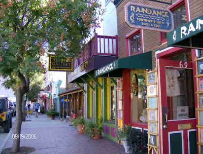
Durango has a nice historic district which has been the scene for some movies (image is from here - which was undoubtly taken before a movie scene was shot) with a lot of nice looking and prosperous looking stores. We took a free trolley (a bus that looked like a trolley) between the breweries and the hotel.

Aug 19 am


In the morning we woke up in Durango and went on our way toward Alamosa. During this time we went over Wolf Creek Pass. Although the pass was about 11,000 feet, it was not as scary as Douglas Pass because the curves (vertical and horizontal) were less severe and the highway was three or four lanes in many places and had good guardrail.

These images are from here. The first image is facing westbound according to the photographer (which I think means the photo is facing east).

We saw at least a half a dozen people on bicycles trying to go over the pass (I think that based on his website content, the photographer of these two images was also a bicyclist).

Aug 19 early pm


Early afternoon on the 19th we checked in to our motel in Alamosa and then went out to the Sand Dunes National Park.

The first image is the entrance to the dune area. I walked about to the base of the high dunes but to the right quite a bit to where the high dunes were just beginning.

The second image is of the dunes in the foreground and the mountains in the background.

The third and fourth images were taken from a grassy area of the dunes.

Although the temperature on the dunes can get to 130F, this day was actually quite cool (in the 60s of 70sF) as a rain storm had just come through.

The sand comes, according to accepted theory, from the San Juan mountains 60 miles to the west (which are plainly visible from the base of the Sangre de Cristo mountains or from the dune area or from anywhere in the San Luis Valley).

The National Park site gives lot of information on this here.

The age of the sand dunes is less certain (see q&A cou
plet 13 here)

Aug 19 later in the pm

We hadn't planned to see this but we had some time after the Sand Dunes National Park and it was on the way back to Alamosa so we stopped at a place called "Colorado Gators".

Apparently, per the website above, in the 80s they had begun to raise Talapia in the geothermal water they obtained when they took over some property.

They bought some alligators to become garbage disposals. The locals started to come to see the alligators (as they are such a photogenic creature). People started to bring them live alligators that had unfortunately been bought as pets and had grown to untenable size.

Eventually, they bought other animals. They have many huge tortoises and some ostriches (last image) and various other things.

The second image is me holding a live gator. The gator is small and has already been fed but still you have to grip the neck close to the mouth. This is a similar hold to the Alpaca on Aug 15, although the gator in this image is about 1 year old and doesn't nurse so much as bite and swollow.

The third image is of an albino aligator. There are only a few dozen of these in the world and they have one there.

Aug 19 late pm

We drove back to Alamosa from the Colorado Gator Ranch, went to the motel and then to the San Luis Brewing Company in downtown Alamosa. The brewery is next door to the District Attorney's Office and near to the county building. In the image is one of their brews, the Hefe Suave (Suave Chief - all their beers are here). This beer had a malt like flavor and was blue-ish and silvery (and unfiltered so you couldn't see through it). Pretty darn good - especially after a big day.